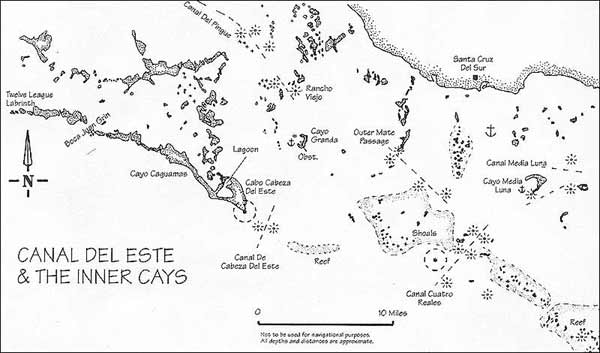
THE MID GULF CAYS: CUERVO, MANUEL GOMEZ, & ALGOD^N GRANDE (SEE SKETCH ON PREVIOUS PAGE) CHART NOS. ICH 1139 &1428 (CUBAN) Equally accessible from the inner route east-west or from the outer cays, there is a group of islands worthy of note. Some 13 miles to the east (80°M) of Boca Grande canal on the inside, or 12 miles north of Cayo Caballones, these wonderful cays offer good shelter and lots of room and opportunity for cruising at leisure. The fishing fleet hangs out around here with their Centres de Acopios for ice, water, stores etc., but in the main the place is pretty well deserted and this group of cays with their smaller cousins could well be deserving of a week or so. These cays also make for a convenient jump-off point for the inner ship canal towards the southeast or if visiting the town of Jucaro further to the north. Cayo Cuervo: The most westerly of these mid Gulf cays is Cayo Cuervo (Crow Cay), which may be entered along a course of 65°M into a crescent shaped anchorage which offers excellent protection. There is a sentry-box type mark on the west side (the light is generally not working) which must be passed about 100 yards to the south around 21°04.0/078°57.9 in anything up to 20 feet. There are some ruins of an old acopio over to the north side of the bay and one small shallow spot half a mile over to the southeast of that (2i°04.3/078°57.3), but apart from that there is nothing to look out for. Cayo Manuel Gomez: Only six miles to the east, the Cuban shrimping fleet moors around a freestanding dock on the east side of Manuel Gomez at 21°02.7/078°50.8 Well guarded by reefs, this cay is made up of a collection of smaller islets in a scattered group; some with beaches, and some with sandbanks blocking the passes between. To the southwest of the cay, a reef extends out for a mile of two, but if you are going east you may pass through a narrow pass at 21°02.2/078°51.0 with 50 ft. available along a course of 170°/350°M. Further east, some two miles away, there is a smaller cay called Algodoncito, with some beautiful beaches on the north side. There is a long submerged reef between this cay and Algodon Giande, so if intending to pass through, then make sure you do it at around 21°03.2/078°48.2alongacourse heading of 045°/224°M. Cayo Algodon Grande: Situated about five miles northeast of Algodoncito, the last of the major cays here is Algodon Grande, but it is definitely the nicest. Over to the north side, just off the beach a small dock protrudes into the blue-green waters. Unfortunately it is in ruins, as are the cabins ashore, but this is what is normally described as "under repair" in this part of the world. This is a real shame for someone, as it really is a lovely spot with a beautiful beach, which being on the north side would have a pleasant breeze. Nevertheless, over on the southwest side of the cay there is a superb anchorage with an easy entrance carrying good water all the way. A submerged reef extends wide out from the southwest tip, with a large stake marking the end of the shallows. Pass this stake about a quarter of a mile off to poll (say 2r05.5/078044.9),aiming450M,andyou'U be in 12-18 feet, all the way into this beautiful bay complete with tiny beaches dotted all around. This lovely little spot, perfectly protected from all sides (including the west), is truly worth a couple of days of anyone's time. Routes east: At this point, the mainland has begun to bulge downwards for a while, so from these cays you may once again return to the outer cays, or take up the main commercial inner route which runs southeast-northwest through the middle of the Gulf of Ana Maria. If choosing this latter option, then merely head approximately 130"M for some 18 miles to the Pasa Malabrigo and the Canal del Pingue. PASA MALABRIGO & CAYO GITANO CHART NO. ICH 1139 Halfway along the route to the canal through the Cayos del Pingue, there are a couple of reefy spots just south of Cayo Malabrigo and lit by a marker at postion 20°53.4/078°29.1. In any case, provided you do not pass between the cay and the light, nothing else around here is shallow enough to cause any real problem. From this light at Pasa Malabrigo, the course to the next major pass (Canal del Pingue) is 125°/305°M for 11 miles. Unfortunately, due to its size and shape, the cay doesn't provide much protection so it is not of any real benefit as an overnight anchorage, but four miles northeast of here, and only a mile off the mainland we find Cayo Gitano. Approaching Gitano at about 70°M you can anchor just off the narrow beach to the southwest (20°57.1/078°26.6). The advantage this cay holds is its shape which offers good protection from the east winds, and fishing boats both large and small use this area to rest up. If you do not wish to return to the Pasa Maladrigo, from Gilano the course to the next important pass at Pingue is 145°Mfor 12 miles. THE CANAL DEL PINGUE (SEE SKETCH ON PAGE 227) -- CHART NO. ICH 1138 Roughly north of the extreme eastern end of the Gardens of the Queen lies an extensive area of reef and small cays which obstruct the main inner channel running the length of the gulf. There is one major passage, some seven miles long, with depths of 25-50 feet along its length, at the Cayos del Pingue. The northwest end of ihe channel is marked by a large black buoy (flashing green light) in 50 feet of water at position 20°47.0N / 078°19.2W with a red to follow a quarter of a mile onwards along a course of 140°M. After this, you may take up a general course of 175°M towards the next marks. Although one should pass southwest of most of the red marks along this canal, and northeast of the greens; just to make things complicated, on occasion you will have to use your discretion and ignore this rule. To reinforce this, keep a sharp eye out for stakes and whithics marking the shallow patches either side of your route. Along the bottom section of the channel, the course will tend more easterly (140°M) through the Canal Rancho Viejo, with a final red marker light in 50 feet situated at 20°41.2N/078"16.1W. From here, the inner route takes a course of 122°/3020M over the top of Cayo Granada and towards the Pasa Mate de Afuera some 10 miles away — see sections following Piedra Grande on page 226 . If going to the outer cays then merely head due south to the end of the Twelve League Labyrinth at Cayo Caguama 10 miles down. THE OUTER CAYS: CABALLONES, ANCLITAS & THE TWELVE LEAGUE LABYRINTH (SEE SKETCH PAGE 221) - CHART NOS. ICH 1139 & 1428 (CUBAN) If you haven't chosen to visit the mid-gulf cays or taken any of the inside routes from Cayo Breton, an interesting anchorage may be found inside Las Auras behind Punta Escondtda on Cayo Cabatlones. In spite of it not being shown on chart No. 1139 there is a reef entry from outside at 20°52.7N /078n03.9W along a heading of 90°M and carrying 12-15 feet below your keel. Within the sound, depths are seven-to-12 feet and shelter can be found over to the cays wherever you wish to position yourself. From the above position there is excellent scuba-diving all along the outer wall just where your depth-sounder suddenly drops off the scale. The presence of the wall, even if a bit intimidating to the novice diver, does make for easy underwater navigation. Just head one way along the edge, and come back following the same route. You should do the deeper portion first, down the drop-off at your comfort/skill level and coming back along the shallower top edge where you will be able to pick up on the anchor, or the boat bobbing overhead. Whatever, as usual, be aware of what you're up to, as I can well remember doing emergency first-aid repairs to a seriously wounded fisherman here, after he'd incautiously put his hand into a hole in which a moray eel had made his lair. CANAL DE CABALLONES AND THE OUTER-REEF PASSES (SEE SKETCH PAGE 221) Between Cayos Caballones and Anciitas, we find the Canal De Caballones where lonely fishing boats occasionally raft together for company. Wide and deep at 20°49.2/078°58.0, this canal is another logical place to pass through the cays to the northern side or further into the gulf to get to the middle cays described previously. If a funny looking barge with a strange blue superstructure is moored somewhere in sight, then it may be the live-aboard hotel described shortly. You may also enter the much shallower Piedra Grande or Piedra Chiquita passes to anchor in the flats there and to stock your freezer compartment, or alternatively continue on the outside for six more miles to Cayo Cachiboca where you can anchor in the western part of the pass. PLEASE, ANYTHING BUT LOBSTER... Be careful when attracted to the seafood on offer here, as my crew have complained bitterly about being served lobster for breakfast, supper, lunch etc,, for a week and a half! That trip, we even made lobster soup for a change. Having left your overnight anchorages to continue along the coast you can again take a mid-morning break to scuba dive in beautifully clear waters over the coral reef and then continue your journey two hours later in the afternoon, cooled, refreshed and thrilled. As before, lower the anchor near the wall for the best dives. Sometimes there are two distinct walls, say one at 20-30 feet and a further one at 70-80 feet going straight down. I've been repeatedly buzzed by inquisitive tarpon off the coast here at 60 feet, just above the second ledge. It's very startling! PIEDRA GRANDE PASS, AND THE FLOATING HOTEL There is an interesting experiment underway inside the Pasa Piedra Grande, consisting of a seven bedroom floating hotel which specializes in scuba and fishing holidays. This passage, through to the other side of the cays, is situated between Cayos Bocade Piedra Chiquita and Boca de la Piedra de Piloto. If contemplating its use to transit through the cays then be aware that it is only five-to-six feet deep at the baron the northern end so it is limited to shallow draft vessels — apart from that, it is straightforward. To get into the pass, enter from around 20°45.5/078°50.6 along a course of 20°M and into 12 feet depths until the far end which lies some half mile away to the north. A warning: The hotel does of course move about, visiting various sites depending on conditions at the time and may well be elsewhere when you arrive. In any case, if it is here, then only experienced skippers should attempt to get close as the side channel where it moors is shallow. To get to the hotel, you wiil have to be prepared to deal with shallow waters in an eastern branch off to the side of the main pass, but if you can get alongside then you will most assuredly be made welcome. You may, of course, anchor in the deeper water available at the southern entrance and take the dinghy to the hotel. As you progress deeper into the side channel the depths will get progressively shallower, so be careful to reduce your speed and look for the stake marking your path. Passing this stake closely to starboard, continue slowly in five-to-six feel of water into the eastern branch of the passage where il will deepen to 10 feet and you can approach the hotel which looks rather like a small Mississippi river boat. Depths alongside are around five-to-six-foot, but note that the hotel frequently moves its base, so this (and indeed all the above) may not hold true when you get here. Other sites: On occasion, the hotel is known to moor in the mouth of the Pasa Cachiboca, a bit further down the cays to the east at 20°42.0/078°45.2, and again it may be anchored on the eastern side of the Canal de Caballoncs which you passed seven miies to the west. If il is in Caballones, then it will sometimes even be round the comer to the northeast of the canal, tucked in near Punta Nicola inside the northwest entrance to the iagoon there. BEACH FRINGED CAYS Proceeding along the coast in any wind north of east, the seas will make for relaxed cruising. The tiny cays are fringed with beautiful white beaches, and coming in over the wall it' 11 take a strong will or a tight schedule to resist pausing somewhere before Cayo Caguamas 20 miles on. There is evidence of hotel construction along the coast there just before the light tower halfway along, but this appears abandoned now, perhaps testimony to the difficulties of investment in Cuba. Doubtless thoughts of retiring to a cay somewhere along the southern rim will have already come to mind, but lake note of such signs. Many are the foreign investors in Cuba who have confessed disenchantment with local business practices, and broken promises. Perhaps this is why the coast here will be so rewarding to cruise for so many years to come.
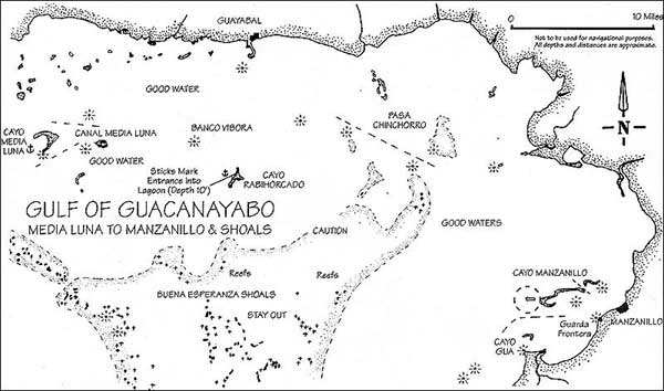
THE EASTERNMOST CAYS & INNER CHANNEL TO MANZANILLO CHART NOS. ICH 1138 & 1426 (CUBAN) As before, you will have noticed your courses needing still further adjustment to compensate for the growing magnetic deviation. Referring to my old charts, still pencil-marked with unerased courses, I see the notation. "Mag Dev seems to have grown to 3-4 deg". Figure it in when deviating from those headings shown here. The Gardens of the Queen come to an end at Cayo Caguamas, so the final stretch between the outer cays and the extreme eastern end of the gulf will best be done along the inside. From Caguamas, you may either go north to Cayo Granada, joining the inner route there, or continue eastwards along a less protected path to a small group of cays surrounding one of the main com- mercial entries for international shipping, the Canal de Cuatro Reales (see description below). After Granada, the inner route passes near these cays, so either way you will bepoised to join it without much trouble. CAYO GRANADA From the outside passage you can come in through the buoyed channel at Cabeza de! Este on the eastern tip of Cayo Caguamas where the fishing fleet has another small hideout. If the light still allows, there's a wonderful sheltered inlet located some eight miles away (30°M) at Cayo Granada and it's well worth making for here if you expect any trouble from the east or northeast. This is a sickle-shaped cay positioned at (20°37.6N /078°14.SW), with good water anywhere inside its bay, and apart from an area of shoal waters on its northwest tip you may enter anywhere on the western side. There's a small and perfectly visible obstruction (a pile) in the bay just south of the middle, but apart from this you should have no problems here. We've used this cay to shelter from a violent cold front which swept in from the east, but in any case it makes an excellent jumping-off point for any of the the coastal towns like Santa Cruz or Guayabal aiong the route to Manzanillo. PASSES ALONG THE ROUTE EAST From Granada, it's an easy eight-mile run I07°M to Pasa Male de Afuera (Outer Mate Passage), a well-marked pass at 20°36.2/078''6.6just off the southern tip of a string of cays reaching out from the mainland. A handy anchorage here is Cayo Guicho just to the north of the pass, on the western side of the cay, and I have used this very spot to pause for repairs to a broken engine on Hobbes. Tired fishermen also use this spot for resting up, and a lot of fun can be had in the clear waters here. Lobster, turtles, and anemones are all visible here and there's good snorkeling on the reef nearby to the south of the canal. The route now bears 135°M along a string of marks to the next pass six miles on at Juan Suarez, whereupon it heads towards the ports on the peninsula of Granma Province. Just below Juan Suarez lies the Canal de Cuatro Reales with handy anchorages available for those who opt for going there direct from Cayo Caguamas rather than taking the Granada route. Canal de Cuatro Reales: This canal is one of the most important entries for commercial shipping into the Gulf of Ana Maria. Best entered from 20°26.5/078<>i.6, juit east of the light on Cayo Carapacho the weil marked channel will take you 230°/50°M through the reef into the gulf. There are various small buildings on the cays here, but you may anchor off quite happily. There are especially good places to moor, some two miles east of the passage, and south of Cayo Blanco. Lots of lobster traps can be found here, and snorkeling will be rewarded by supper, but once again do not molest the traps — catch your own. The main inner route passes just a couple of miles to the north of the channel. If you wish to travel west, then a course of 300°M will join you up with it at Juan Suarez, while a course of 65°M will put you just south of Media Luna on the route east towards Manzanillo. WORTHWHILE FOR SHELTER Along the way to the Pasa Chinchorro (approximately. 90°M — 30 miles) you'll pass closely by two other cays worthy of note. Media Luna, and Rabihorcada. (See chart on Pg. 230). Media Luna: A large crescent shaped cay offering excellent shelter on its western side. There are only mangroves on offer and it is not very exciting, but with a bottom mixture of mud and sand, this is a good place in a blow. There is a dinghy channel in on the north side of the crescent, which goes in some 50-100 yards. Cayo Rabihorcado: When using photocopies, or even original black and white charts, be careful not to misinterpret them and think that the reefs comprising the misnamed Esperanza Buena (Good Hope) bank to the southeast are really cays — they're not. The first time we passed along here, using photocopies (of photocopies), we made the elementary mistake of bypassing Rabihorcado and heading for what we'd assumed was shelter 10 miles further east. Only when the expected cay failed to pop up over the horizon did we realize our error, and it was a bit of a scramble to get back to Rabihorcado before nightfall. Mind you, we did thereupon discover a strange inner-world inside the cay, entered through a narrow stick-marked channel on the western side. This channel, not at all obvious and only 15 feet wide, lies in the second shallow bay from the northwest lipand progresses southeast from 20°31.2N / 077°38.1W into a series of secret lagoons splitting the cay. Lying on the north side of a tiny islet blocking the mouth into the lagoon, it is only 6-foot deep at the entrance and care should be taken to keep hard over to the right of the channel as you pass the islet. If the entrance is a bit tricky, the deep and totally hidden anchorage is more than worth the trouble and really sums up what cruising the southern cays is all about. Clear, black, limpid waters, creepy with presence. Of what, we can only surmise. At the other extreme of this large lagoon, there is an exit onto the eastern side of the cay. Unfortunately, it is shallow on that side so this is only for dinghy use. Even if you don't want to enter the lagoon, there are a couple of nice bays on the western side, and the cay itself has a certain "body" to it, which makes it a good place to stop. FINAL ROUTE EAST From the top of Rabihorcado, the route to Manzanillo takes us past a couple of shallow reefs, the most notable of which is just before the Pasa Chinchorro. This bank, difficult to see from a sailboat deck, is markedbyalargestakeat20°31.4/077't27.7, and you would be wise to go around to the north of this. The pass now lies 3 miles east, at 20Q30.0N / 077°23.6W, and itself is marked by two lights between which you proceed. Passing through the canal at Chinchorro, it's a straight run (126°M for 17 miles) to Manzanilloon (lie mainland coast and guarded by three or four small cays right in front.
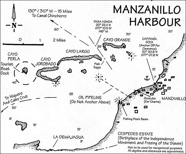
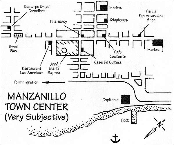
MANZANILLO CHART NO. ICH 1138 (CUBAN) This provincial city seems to have seen better days but still retains a certain charm with its malecon (sea-wall) edged with tiny public parks. The potholed main street runs parallel and at its northern end is lined with wide sidewalks sheltered by sagging, overhanging roofs. Supported by pillars, these roofs give it an intriguing if rundown colonial aspect. Further in, there are several older buildings around the main square where there is a museum, various bars, and a pretty good peso restaurant. In addition, there is an excellent proveedor de buqu.es (ships'chandler), amarket; and last,but not least, the most friendly people in Cuba. Originally a smuggling port, but now dealing mainly with the more legitimate transport of sugar and general cargo, this is the best chance you will have for reprovisioning along the coast and for touring the mountains to the southeast, If coming in from an extended cruise among the cays you're probably out of the habit of checking in, but this is one of the more major cities along the coast so they'll insist on proper documentation, and to speed this process up it is best to call the Capitama (the port captain's office) before arrival. We never used to get a reply from any of the harbor authorities here, but recently there has been an improvement, so if you call "Portuaria Manzanillo" they'll put the capitam'a onto standby for your arrival. All official communications in Manzanillo seem to revolve around VHP Channel 03, butremembertousethemtenw/wna/switch selector on your radio or you won't be able to transmit and receive. If there is no reply on 16, switch over. Using this frequency, you can even get a ships chandler to come out to your boat (see below) to deliver supplies, so leave the radio permanently on Channel 03 while you are in port. If you get no reply to either channel, then just show up as described below. Most people do. Entry: Manzanillo is hidden behind a small group of cays. If you wish, you may go round them to the north or south (the main commercial routes) but there is a more convenient passage between the cays right in the middle at Pasa Honda, (enter from 20°22.4N / 077°10.5W) which is just as easy. Pay no mind to the two dozen or so wrecked trawlers on the cay; they're just being disassembled. Mooring: The Capitania lies behind a wharf on the northern end of the town, near a cluster of small fishing boats, just past the end of the seawall (the maiecon). You should moor a short distance off, in whatever depth makes you comfortable and wait for the authorities to come out from the wharf there. This can take some time, but once accomplished, the officials are some of the most friendly you're likely to meet. International arrivals are catered to, and even if you've already been in Cuba for some time you'll still have to face a medical/agricultural inspection. One thing you will face is a strange regulation prohibiting your disposing of any waste ashore. Saying that this means you'll sooner or later have to dispose of it over the side should ensure a more reasonable attitude.
Some travellers have been told that someone should remain onboard at all times, but as this is so inconvenient nobody takes any notice of it. You're out in the country now, so reason seems to prevail more readily than in somewhere like Havana. One feature of the harbour here is the strong surge which sets in every evening, especially in the winter and spring. This surge can be alarming at first, but the holding is so good that you learn to trust it. The nearby dock is in fact a beached steel pontoon, and you may tie the dinghy here when going ashore. Just be careful to remember the surge when mooring alongside, and make sure the sharp edges cause no damage while you are away. Small brown boys and grey old men fish from the end of the dock, but 1 have never heard of any problems with dinghy security here. As a matter of fact, they'lllookafteritforyou if you've screwed up. Most evenings, on the seawall opposite your mooring, a few slow, rheumy eyed, townsmen hang around listening to boom-boxes. But at weekends, hundreds of more lively inhabitants gather to dance in the square just a hundred yards up from the capitam'a, while the people who operate the music,alsosciilittle sweetmeats.The noise can be a bit intrusive at first, but it's wonderful to see all these people bogeying in a way the average cruiser can only dream of. If you've got the right attitude and want to join in, you'!! be made most welcome, and some lithe soul will soon be showing how it's really done. But hey, this is another reason you're here — not just for the cruising.
Downtown, there are a couple of produce markets, and a couple of stores (Panamericana) which sell foreign stuff at foreign prices. Better to obtain pesos from any of a dozen change artists in the street opposite, as this is one of the towns where it is actually easier to spend pesos than dollars. Around the Jose Marti square, an abundance of oddly Moorish architecture stands out, and more street peddlers offer snacks. Here you may buy an oyster cocktail under the arches, or a roast pork sandwich cut steaming from the joint, while if you prefer a proper restaurant, the America will sell you an reasonable meal; pork, rice, vegetables, and all the trimmings for 20 pesos. Bars, off to the side of the square offer rum (Pmillo is the local hootch) at a peso a shot, while beer comes more expensive at one and a half. I can live with that. A tale: In 1996, at the same restaurant described above, I once attempted to purchase a meal, but on this occasion had no pesos. Dollars are not accepted here, so while the waitress hung onto our order we went in search of amoney changer. Rapidly returning (nothing is easier in Cuba), we seated ourselves, only to be visited by a delegation of waitresses. They'd come to ask the rate we'd received, and to establish that we'd not been cheated by anyone! If you wish to get about town, the quickest way is to flag down any of the horse-drawn carriages which ply for hire along the roadside. Room will be made for you, and you may alight wherever you wish. It costs a peso, as does the much more infrequent bus. Truly bliss, as you clip-clop, rattle and sway, along the seawall road. Boatyard: On two occasions I have moored for long periods at a boatyard about a mile down towards the southwest. If you have to use the facilities here (haulout or machine work), then permission will have to be obtained from the management who will liaise with the capitania officers. Walk down the nialecon, about a mile to the south, and you'll come to it. The yard itself consists of a slipway where large tugs and steel barges are repaired by arc-welders, or otherwise attended to by muscular men wielding large sledgehammers. The wharf there is used mainly by tugboats and protected by large dirty black tires suspended by chains, but it makes a handy dock if you can wheedle permission. Charts: You may purchase most of the ICH series of charts here in Manzanillo at the offices of Geocuba. Just walk about half a mile southwest of the boatyard, to where a long dock extends out, and a sign declares that this is now a Zona Militar. Looking more like an officers club, a collection of pink buildings surround an abandoned stage. Slogans and large paintings of the maximum leader adorn the podium and next to this are the buildings which house the offices and the chart stores. Hotel Guacanayabo: Up the hill at the southern end of the town, it can be reached on foot by taking an extremely long, narrow set of steps up the hillside. The hotel is a pretty depressing place sometimes, especially when it's darkened by electricity cuts in the off-season, but it does have a swimming pool which may tempt those who have had it up to here with saltwater for the time being. This pool is a fascinating place on the weekends when it fills to overflowing with the townspeople, all seemingly intent on fun, but nobody fighting over it. Although I've met the most wonderful types here, ranging from hustlers and hustled, be careful about what you say to people in the bar and don't get involved with shady characters who may well be a lot more official than they pretend. It was here that my good friend Brendan (a droll Irishman) offered the advice, "Don" t ever trust a Cuban without biceps!". He may well be right. Telephone: Although you may make international calls from the hotel, there is nowhere in town you may presently send an international fax from. Supplies: The town does haveaproveedor de buques (ships store) downtown, which supplies provisions direct to your boat at wholesale prices. Operated by Sumarpo now, this service is perhaps most conveniently contacted over the VHP on Channel 03 by calling "Sumarpo Manzaniflo". For several years, the store has been staffed by the admirable Alberto Lorente, who speaks English and understands the needs of yachtsmen, so do not hesitate to call on the radio even if your Spanish is not up to snuff. Sometimes he even accompanies the officials out to your boat to welcome you to the port. They will also arrange fuel to be brought out to your boat at .60 cents/litre. Although at first glance unprepossessing, this town rapidly grows on one. To tell the truth, although I didn't think much of it at first, over the years, I have come to appreciate Manzanillo more and more. Stuck out in the backwaters of the country, it seems to have retained a sense of humor about itself, and an attitude that seems to say "Hello pardner..." We are not the only ones who've stayed longer than planned. In the event that you are planning to extend your stay in Cuba, then you will find that this can be accomplished here. It does require however, a visit to the Hotel Guacanayabo to pay $25, and a subsequent visit to the immigration offices. This last is about six blocks north of the capitania along the waterfront road I ° Mayo, and just past the shoe factory. Leaving: Once again you have to arrange clearance and official visits before leaving the port. If you want an early departure, then this is best arranged the day before at the capitania offices. You may obtain ali necessary documentation for onwards travel here.
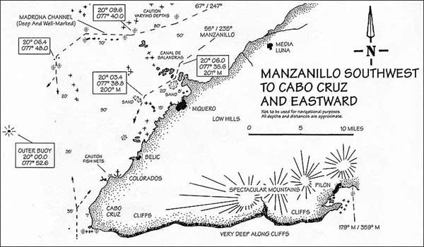
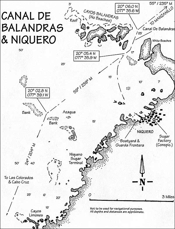
SOUTHWEST TO CABO CRUZ CHART NOS. ICH 1138 & 1137 (CUBAN) There are are two routes to Cabo Cruz in the southwest. The inner passage takes you close to the coast and is visual all the way with a couple of tricky wriggles through more or less vaguely marked channels (See charts on Pgs. 235 and 237). This route takes you past the town of Niquero and the beautiful harbor at Cabo Cruz. The outermost route, tending further away from land, is better marked, but unfortunately does not allow a convenient resting place for preparing for the trip round the cape. It is perhaps more suited to larger deep-drafted vessels which might not need or wish to rest up overnight. Interestingly enough, the official south coastpilots (the service is called "practices" if you should ever require it) receive their training in these waters. THE OUTERMOST ROUTE Taking the outermost route first, leave your mooring and approach the western tip of the cays fronting Manzanillo. There is a light on the end at Cayo Perla, and a 22-mile course from here along 247°M will run you into the light at position 20°1 1.2N / 077"35.6W about eight miles north of the town of Niquero, near the Madrona Channel. Give the light a safe berth (pass it on your right, as it sits atop a coral head), and set a course of 260°M for four miles. This now takes you to the beginning of the 10-mile channel which will first tend west and then southwest at 20°9.5N/077°45.0W.Finally, leaving the channel you can now set course 15 miles due south to Cabo Cruz, on the other side of which lie the cliffs of the southeast coast. THE COASTAL ROUTE If you prefer to take the more common inner route, close to the coast, then clear Cayo Gua southwest of Manzanillo by a couple of hundred yards to port and continue visually, southwest along the coast in comfortable water. A 25-mile run wif 1 bring you to the Balandras Keys jutting out just before you come to the town of Niquero. There is a narrow channel through the cays running 217201°M which, although marked, will require some care. You'll find the channel entrance near a position of 20°06.0N / 077°35.6W. Thischannel is boundedby white beaches on the southern side, but has none on the north. Look out for a rather conspicuous sandbank to your port immediately upon leaving and dodge round it to the north. At the exit to the Balandras Channel the route continues past the town of Niquero (see description), continuing 240°M to the next pass some three and a half miles on at Azagua. This pass is marked only on its northern side, by two stakes, but this may change with time or opportunity. Just be prepared with a sharp lookout for sandbanks on either side even though the channel itself is deep. From here a course of 204°M will take you seven and a half miles to Punta Las Colorados where you may also find a sheltered bightwith good water around 19°55.7N /077°41.9W. Note that some halfway along this final route there is an obstruction off the cays near Limones a mile or two up from the village of Belie, sconce again watch for the mark. The rest of the way is best done visually, about a mile offshore until you come to the reef which extends southwest from the extreme tip at Cabo Cruz. Along your journey between Manzanilto and Cabo Cruz, there are three places which 1 would recommend as rest stops before rounding the cape.
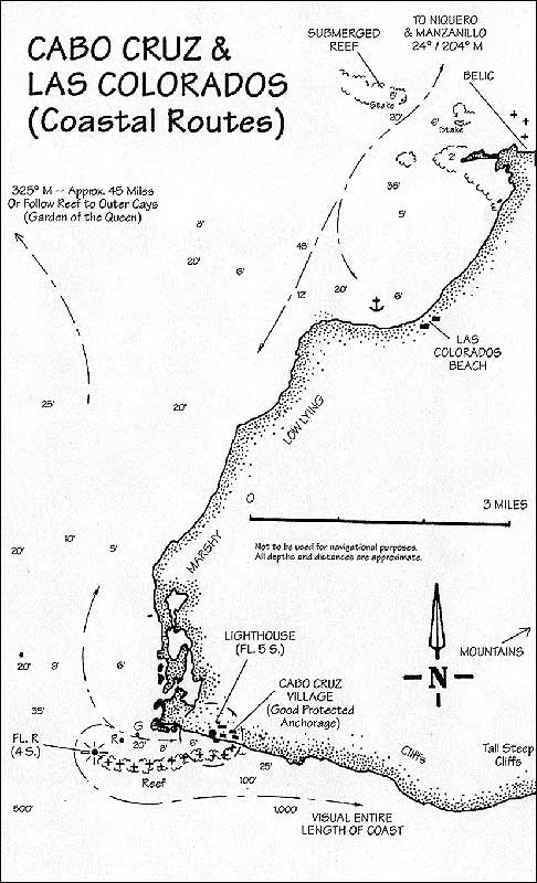
NIQUERO Just south of the pass at Balandras, this port should not be approached from the north, but rather west or northwest. This route passes close to Cayo Niquero, a small island west of the town and avoids the shallows on the direct line between the town and the pass. Although the fishing docks over to the north will tempt you, it is best anchoring on the other side of the pilings at the southern end of the town. Here there is a small boatyard with a white Guarda Frontera building next to that. This is, in any case, where your documentation will have to be done, so you might as well be here from the start; and you will also avoid the smell of the fish processing plant. If you don't draw more than seven-foot you can get alongside one of the fishing boats at the boatyard to sort out your papers, but you'll probably have to anchor off for the night. Although the town is open to the west, the holding is good once you've set the hook. Formalities will not take very long, and you wi!I be free to go ashore in the dinghy, leaving it alongside the docks there. Ashore, Niquero is dominated by the picturesque sugar factory and associated wooden buildings, with fading filigree decorations along the main drag downtown. A 10-minute walk, left from the dockyard gate will take you there, past small wooden houses and along dirt roads until you get into the central part of town. There are several small restaurant/bars in Niquero, and you can purchase shots (ask for Pinillo rum) for a peso at roadside kiosks whenever you feel the urge. The Communist Party HQ here, is housed in an old and rather quaint building, near the station with its splendid red fire engines, along with the 'phone service, the market, and a small park where you may relax for an idle hour or two. Just like Manzanillo, the people of Niquero are extremely friendly, making the most of strangers, so be prepared to visit someone's house to sample the local brew and meet the grandparents. Only don't expect to get back to the boat on time. The girls have green eyes, the men are good drinking companions, and you'll not regret a stop-off in Niquero. As an aside, this will be one of those places where you notice that the town comes to a complete and utter stop when the soaps come on. Apart from small clusters gathered outside any house which has a television, the streets are deserted at nine o'clock; whispering groups stand for an hour, peering in through the open doorways and windows of total strangers without anyone feeling at all embarrassed. Maybe this is why you have to get there early if you're going to patronize the peso restaurant downtown. LAS COLORADOS BEACH Southwest of Niquero, there is another overnight shelter in the bight off Colorados beach just north of PuntaColorados. There are no real dangers on the way in, but while it is stiil daylight, take note of any evidence of nets strung out from poles in the water. There are usually a few of these off the point at Colorados and you will likely be leaving in darkness for the trip round the Cape. Plot them on your charts for later avoidance. This is an interesting spot, not merely for the abundance of life below the surface amongst the turtle-grass, but for more serious reasons. You are now anchored off one of the more historic sites of the western hemisphere. No matter what your political persuasion, you cannot help but feel moved by the sight of the beach and the mangroves where Fidel Castro, his brother Raoul, Ernesto "Che" Guevarra, and their compadres landed in the darkness of Dec. 2, 1956. By the time the smoke of ambush had cleared only 12 of the original 81 were still alive or not captured, and those survivors could only flee through swamp and bush to the nearby hills, starvation, and struggle. From such inauspicious beginnings have enormous changes come and their worst enemies cannot but salute their bravery.
THE HARBOUR AT CABO CRUZ The very last spot before rounding the cape, this offers a super little anchorage in clear waters at the foot of a marvellous lighthouse. Although at first glance open to the winds, it is also totally protected by a reef from the force of the seas, and moreover positions you perfectly for an early morning departure. From here, you may easily judge the conditions and make your travel plans accordingly; allowing you to arrive at any of the nearer south coast ports in only a couple of hours. There is a Guarda Frontera station here, but the official presence is not large enough to handle international arrivals. For that you will have to use the port of Manzaniilo within the gulf to the northeast. For internal cruising however, the officers here are friendly and efficient, and clearance only takes a couple of minutes — especially if your Gia de Recalas already shows this as one of your intended halts. To enter the harbor, approach the extreme western end of the reef where it curls like the tail of a comet from the tip of mainland and come in a couple of hundred yards north of 19°50.2 N / 077°45.0 W. where there isaIargesentry-boxlight(F1.4s.) and the depths are over 20 feet. At this point you may go 100°M to the following R/G. lights, some 800 yards away, and well inside the sound itself. The reef outside here is quite jagged, and breaking all the way, so there is no problem with positioning yourself. Aim slightly to the right of the lighthouse and the depths will slowly shelve to eight feet some 300 yards from the base. There are a few small yellow moorings just off the concrete docks there, so ask permission of any of the local fishermen (or the amiable gentleman from the Guarda Frontera who is peering at you from the dock) and moor to one of these. This is a surprising little village, notable for the neatness of the tiny flower gardens in front of the fishing cottages which line the only road; and as is usual in the province of Granma, amazingly nice people (see comments about Manzaniilo and Niqucro for this too). In 1996, we passed a wonderful and totally unexpected afternoon in the company of some twenty local agricultural students on a tractor-powered jaunt from nearby PortiUo. For hours it seems, we danced wildly, eating stewed mutton (a sheep had been sacrificed to the excursion) and drinking strong rum, in a small hut on the foreshore. Then, prowling the shoreline at the foot of the tall cliffs, we made our way to a wonderful cave and swam beneath the dripping stalactites within its dark interior. But the star attraction of Cabo Cruz is undoubtedly the wonderful lighthouse, not a hundred yards from your mooring. Solidly constructed with crcamish brickwork, and supported grandly by large columns, it makes a splendid sight at any time of day or night. To leave before sunup, you will have to inform the Guarda Frontera the night before. But nevertheless, be prepared to walk to the compound (to the left on the hill leading out of town) and wake the duty officer if you wish to depart in darkness. They will probably prefer you to stay until daytime, but if you have a strong light on board (you should have) then it is a straightforward exit. Just remember to pass well to the west and south of the reef lights as you come round; but from here on you can hug the coast closely as you travel east along the massive cliffs which now line the rest of the extreme southeast coast.
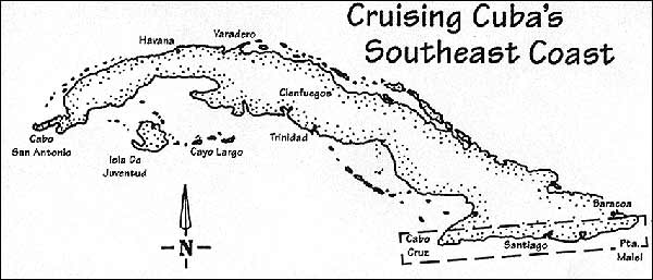
CABO CRUZ TO PUNTA MAISI This chapter, albeit smaller than the rest, is nevertheless going to introduce you to what is without adoubt, the most spectacular coastline in Cuba. Between the two acutely angled capes at either end, this sometimes arid coast is bordered for the next 220 miles by rocky cliffs and awesome scrub-covered mountains, one visible from as far away as Jamaica. Having coasted the Cuban cays, or perhaps come down from the U.S.A., this dramatic change will require a different technique, the key to which is merely avoiding travel in strong south winds. TACTICS The coast is evenly spaced along its length with secure harbors, each about a day-sail away from its neighbor. Once embarked on a passage however, there are few alternate shelters and passages can be long; so your preparations must be careful in this regard. Luckily the winds along the coast are usually quite predictable and can be calculated according to the time of day with some accuracy; thus leaving the question of passage planning to revolve around scheduling and mechanical efficiency, i.e., leaving in good time, and not breaking down along the way. As a matter of fact, the median wind velocities vary between seven-to-eleven knots in summer and five-to-seven knots in winter, except for the eastern tip where the winds can sometimes be stronger. If you don't go berserk you'll more than likely have a nice gentle sail along what otherwise appears on the map to be a difficult stretch. CURRENTS Going west: The main current through the windward passage between Haiti and Cuba runs westwards, and this can be used to some advantage if you are going in that direction — just stay two or three miles offshore to gain its benefit. Going east: In spite of the above-mentioned current, there's usually a goodly countercurrent near the shore running eastwards along your route, especially in early summer. There isn't much in the way of outlying dangers off this coast, so to gain up to three knots sometimes, stick tightly to the coastline like glue; and I mean within hailing distance in many places. Try it, and see your logged speeds going up. As an aside, but still on the subject of cruising offshore, the channel between Haiti and Cuba is heavily patrolled by U.S. naval vessels. If you stray out over the 12 mile limit of Cuban territorial waters you are quile likely to be stopped and/or interrogated by radio. To avoid this hassle, don't |