Moor alongside the guardhouse at the base of the flagpole and present your papers. The last time we were here, checking-in took not more than five minutes and we were given permission to depart in the morning without having to return to the dock, so request this facility. Although I do have reports of some boaters being recently met with puzzled looks, we ourselves have been offered all kinds of assistance by the authorities here, and our logbook once noted that they were the most helpful officials we'd met. You will probably be asked to moor a Sittle way out from the dock and among the other fishing boats at anchor. The holding is excellent anywhere in the harbor so just make sure you're out of the main channel, and dinghy back ashore to have a look around. Leave the tender at the dock, walk between the warehouses near the Guarda Frontera post to the main gate and let the gaieman know you're leaving. Strange sights await you following (he road round to the right. Grim Eastern-Block concrete apartment-buildings, miserable huts, nicer streets with neat dwellings, a baseball stadium, and squealing pigs contrasting with children playing happily at the side of the road. The walls of the more primitive huts among the mangroves are made of roots bound into wali-sections and they are peopled by charcoal-burners using only the most rudimentary of techniques (they don't exclude the oxygen). There's even a tiny rural boatyard where you' 11 see boats being carvel-planked at the side of the road.
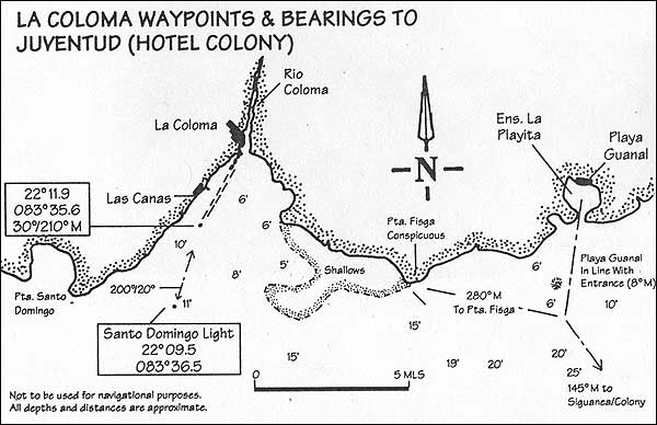
ROUTE TO DARSENA DE SIGUANEA (ISLADEJUVENTUD) CHART NOS. ICH 1147 & 1145 (CUBAN) It is important to note here that you cannot travel in a straight line all 48 miles southeast from Coloma to Siguanea, the small harbor near the hotel Colony in Juventud. The shallows of the San Felipe and Los Indios cays intrude slightly on the course making it necessary to take a gentle eastern arc on the journey. If you don't wish to skirt those cays visually, you can go east along the mainland for some 12 miles after the outer light and steer a direct compass course from there. Avoid the shallows just southeast of Coloma by going out to the outer Santo Domingo light and then going east, following the 15-foot contour. When the prominent Punta Fisga headland bears 280°M and you can just see the village of PlayaGuanal through the mouth of its bay (say 008°M), then a direct course of 145°M should take you to the Punta Buenavista marker off the west coast of Juventud. You can now go south/southeast, paralleling to the coast for about 10 miles to the harbor. Otherwise, just use whatever electronic aid you have aboard in order to get to a point 21°37.ON / 82°59.2W where the Siguanea entry channel begins. On the latter stages of this run you are likely to come across a haphazard multitude of lobster-pots. It would be a bit of a pity for you to blot your copy book and be towed ignominiously into some village harbor in your shiny white boat, so keep an eye out for them. The assorted dinghies attached to the major fishing-boats tend the pots, but only God knows just how they find all these scattered cages below the surface. We've looked down with snorkel and masks and found the cages absolutely packed with lobster... do not molest. Be especially aware if you see dinghies fussing about close to the mother-boat as they may be laying out nets. They seem totally unconcerned by your presence and will gaily watch your approach until the last minute and then begin to lay their lines directly across your path. Meanwhile just to let you know it's not personal, they're waving happily all the time. Oddly enough, the fishermen on the northeastern side of Cuba are not as demonstrative, and perhaps this is a natural outcome of the officially encouraged paranoia over there. But there is also a lot more evidence of needlefish, leaping hound-fish, playful dolphins and the like on this side too. Are the two features connected?
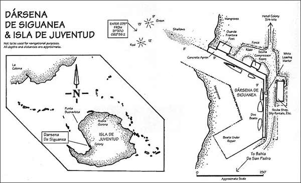
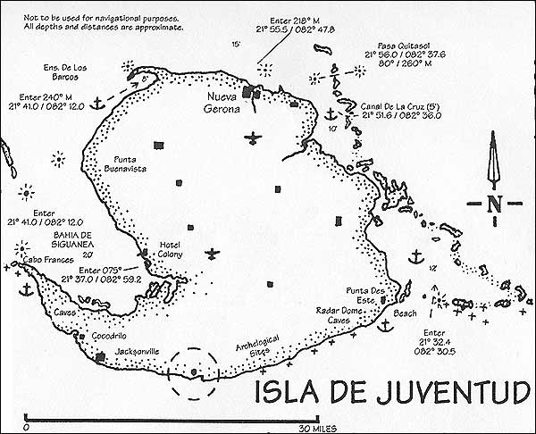
ISLA DE JUVENTUD This island (population 100,000) has had other names since it was discovered by Columbus on his second journey to the New World in 1494. He called it La Evangelista then, and it was once even called La Is la de Tesoro (Treasure Island) and may even have been used as an inspiration for R L Stevenson's book of the same name (weli, everyone claims this one). Later still, it was called the Isle of Pines, by which name it is still known in some places. In 1978 the name was changed to the present "Isle of Youth" after the agricultural facilities dedicated to training young people from all over the socialist world. Previous to Columbus' arrival however, it was home to other groups of indigenous Cubans like the Ciboney Indians who left their marks on the walls of caves in the south and at various other sites inland. The island was colonized by the Spanish between 1494 and 1898 and after the Spanish-American war the North Americans had bought up half of the total iand area, excluding most Cubans from the territories by 1925! During 1870, the Cuban patriot Jose Mart) (whose name is still invoked by both sides of (he political debate) was deported here, and in the early 1950's Fidel Castro too was imprisoned near the capital Nuevo Gerona. Although the island is relatively flat {the highest point is 950 feet) the mountains which do exist are close and easily seen from the coast, making the place look most impressive from some angles. The island has several anchorages, one large port and one marina. OVERNIGHT OPTIONS AROUND JUVENTUD For vessels drawing up to eight feet, especially good shelter from the prevailing wind is to be found in the Ensenada de Barcos just on the northwest tip of the island. Enter northeast from anywhere around 21°54.0N / 083°01 .OW, and anchor where your echo sounder indicates. Again, for deeper waters, you could find refuge amongst the cays to the NE of the island (Los Inglesitos) if you make sure your anchor has gripped. There is a large sheltered bay, protected by a long string of cays down on the southeast corner. It has a well marked and wide entrance at 21°32.8N / 082°30.6W and depths inside of 10-12 feet. Really large vessels (15-foot draft) can shelter just south of the light nearby (Punta del Este on the mainland), but they will have to be careful to enter west of the reef there and come in from that side at 82°34.5W. And again (subject to the warnings below) there is the bay of Siguanea along the west coast. There is too, the main island port of Nueva Gerona which handles large vessels, and finally the marina near the hotel Colony (the Darsena) which can take yachts drawing up to nine feet. DARSENA DE SIGUANEA HOTEL COLONY CHART NO. ICH 1145 (CUBAN) Merely a notch in the coast immediately above the bay of San Pedro, this small but sheltered harbor serves the hotei Colony, originally built for the exclusive use of the North Americans who controlled the island before the revolution. In addition, it is near the site of one of Columbus' original landings in 1894. Perhaps conveniently for some, this tiny harbor can handle international arrivalseven though you may have to wait some time for the officials to arrive from the main port of Nueva Gerona 30 miles away by road. On your approach to the harbor you will see the hotel a mile or so north. The hotei (itself a mile or two south of a couple of iron wrecks), is easily recognized being a large white flat-roofed two-story building with a long narrow walkway leading out to a pavilion dance floor 100 yards from shore. Do not be tempted to approach the pier as the water there is just barely enough for shallow-draft boats. We've found less than four-foot on the approach and even the hotel dive-boats collect their divers from the harbor down the road. The hotel caters mainly to scuba-divers from Germany and France, but the harbor is also a convenient cruising base from which transport and other inland tours can be readily arranged. ENTERING THE MARINA Enter the marked channel from position. 21 "37.0N / 082°59.2W steering 075°M towards the large white "screw" on the inside. You'll know it when you see it, but it's really meant to be a locally-found prehistoric shell. Keep to the right of the channel until inside, where the staves hold back the banks, and dock at the Guarda Frontera wharf immediately on the left where the large patrol-boat usually moors. The Guarda Frontera are friendly enough (if you play the game), but it seems that clearing in is taking longer and longer compared with a couple of years ago, so be prepared for a long delay. The marina supervisor's office is in the building alongside the eastern edge of the dock and also serves as a storeroom for marine supplies and the dive-shop. Marina charges are about .45 cents/foot and electricity is available by twisting the bare ends of a supply line onto your plug. Water is supplied from the dockside tap by your boat, but the water itself is of dubious quality. WARNING: STAYING HERE MAY BE INJURIOUS TO YOUR POCKET AND YOUR HUMOR I seem to have a growing list of complaints in my notebooks from other cruisers who have visited this marina over the last year, and even if the following seems to be an excessively gloomy report, it is obvious that all is not well with this particular marina. The first thing to look out for is additional charges for bringing customs officers from Nueva Gerona to inspect you upon entry. If you're already legally in the country, no such charges should apply as you have already cleared customs. You do have all your original documents and receipts don't you? Most of the diving takes place off the western tip of the island (the tail of the comma) but the area is also claimed to be a submarine preservation site, and in yet another scandalous effort to extort money from you a guide is required to accompany you from the dock. It seems to cost much the same if you take one of the organized dives, but the $56 fee (two tanks, with a beach-lunch) might be a bit over-the-top for a cruiser with his own boat, all the gear, and hundreds of miles of unsupervised diving immediately behind or ahead of him. Especially when you consider that you could get a package tour rate of just a bit over $30 per day (room, food and diving), when booked overseas. Unfortunately too, again I have to write that reports are regularly coming in of problems being made for yachts actually moored outside the confines of the harbor. I know of more than one which was threatened by various dive-boats who demanded fees from them, even when they weren't diving. Demanding to see authorization with a proper receipt book has been known to deter this sort of behavior, and there can be no complaint if you refuse to pay anyone not duly authorized. Another black mark (when anchoring out in the bay) is that the Guarda Frontera try to make you moor where they can see you, and want you to pay .35 cents/foot for the privileged of being watched. As usual, "It's for your security, Senor", but once again we all know it isn't. To my certain knowledge, refusing to pay this charge led to one yacht being forced from the shelter of the bay in a storm. Be careful too of yet another little dodge, that of trying to charge you an extra $20 for Customs clearance out of the port when leaving. The authorities in Havana and elsewhere have repeatedly stressed that there is a one-time customs fee upon entry into the country itself, and that it is not repealed anywhere else once you're legally in. Finally, neither should you pay for a second Cruising Permit/Safety Certificate, like the one you got in Havana. That one has a full six month life-span, valid even though you've left the country and returned. With the increased traffic along the coast seems to have come an increased aggravation factor, and this port seems to be host to all the worst practices. As a result of all the above, some yachts are finding that it's just as convenient to anchor out further round the SW lip of the island where no one can charge you, where the view and the waters are as good, if not better, and where the only soaking you get is in the sea. Hopefully, things at Siguanea will have changed by the time you get here, again returning to the old friendly ways we used to be accustomed to. DIVE ORIENTED HOTEL The 54 room hotel is crowded with regimented German divers (upwards of 150 when we were last there) who arrive on package holidays. Weirdly (to this more relaxed Caribbean diver), they are allocated cards which are subsequently clipped every time they dive to ensure they don't do more than the package allows. In the mornings you will be woken by trucks bringing the divers to the docks where they board the boats. Check out the compressor system near the gate. It's the most sophisticated I've ever seen in daily use anywhere in the West Indies. And to cap it all off, the resort has its own recom-pression chamber at dockside! The hotel is a mile away down a straight road. You know you need the walk, but rub on lots and lots of repeSlant. Tours to the decorated caves at Punta del Este (once again you must be accompanied), rental cars and other island transport can be arranged there. For those who need it, an air ticket to Havana cost $17.00 in 1996, and it'll cost an extra $20.00 for the bus from the hotel Colony to the airport. The restaurant is particularly good and there is a game room for any bored children on board. Quite apart from all the problems in the marina (and maybe they haven't applied to you), one can have quite a good night here, and if you're at al! sociable you will have already been befriended bypeopleat dockside, some of whom may have also come from Havana or up from the southeast coast and thus may already know you. Some will doubtless encounter you somewhere near the bar/ game room of the hotel and when that environment palls the party can move to the pavilion at the end of the pier. Purchase your booze by the bottle in the hotel store early so as not to have to drink expensive shots at the bar later on. You can keep it at your table, and in any case you'll need to be a bit meriy to survive the mosquitos on the walk back. There is also the sound of the watchman patrolling on the concrete outside your window all night. As is ihe norm in Cuba, he peers in unashamed at every opportunity until he gets bored and slips away to sleep. DELAY CLEARANCE UNTIL DIVERS DEPART Clearance out is best delayed until the divers have left at 9:15 a.m., but you should be ready to leave immediately afterwards. Whatever, ensure that your bill is paid well before the last minute, and double check it, especially the additions and extras. There is likely to be a long delay with little or no explanation at the guard post. Don't let it spoil you humor; after all, you're leaving. There are two potential routes east from here. One will take you over the top of the island via the port of Nueva Gerona, and the other allows you to take the outer route along the south coast of Juventud and along the cays. If you draw more than eight-foot take the southern route (sec Canal de Rosario). SOUTHERN (OUTER) ROUTE BELOW JUVENTUD CHART NO. ICH 1145 (CUBAN) Head for the point which you can see 13 miles away due west and come round along the bottom edge of the island. Do not pass too close to the point itself as it is shallow there, but pass some two miles north of it, or even by the main entrance channel around 2P40.6N/083°12.4W. The 44-mile southern coastline is rocky and sloped, but sometimes, due to the trees, it can appear to be an escarpment. There are few natural harbors along here but if you don't draw more than five-to-six feet you might be able to use Caleta Grande at 21°31 .ON / 083°07.OW. There is a small dock inside serving the tiny villages of Cocodrillo and Jacksonville, originally settled by Cayman Islanders in the early part of this century. English is still occasionally spoken here as a result, and family ties loosely bind the two regions. The eastern half of the coastline is mainly beach protected by an offshore reef, but once past that you can come into the large enclosed sound (10-15 feet inside) on the southeast corner of the island just past Punta del Este. Enter around a position of 21"32.8N / 082°30.5W and anchor inside, anywhere you see fit. The bay here is wide, and shelter can be found from any angle of wind. As mentioned before, you can also come round from the west, behind the reef off Punta del Este and anchor offshore. We have in the past found a passage in to a small dock which lies in some six-to-eight feet of water at 21°33.6 / 082°32.8, but access is too tricky to be recommended for anything oilier than a shallow draft vessel (keep west of the stakes marking the way). In any case, if you do venture ashore by dinghy there are impressive Indian designs all over the walls of some prehistoric caves in the immediate vicinity. Further along, you can anchor off any of the cays which offer protection, but make sure you have entered through the reef west of Cayo Avalo at 82°)O.OW if you're going to take up this option. NORTHERN ROUTE TO NUEVA GERONA CHART NO. ICH 1145 (CUBAN) This 35-mile passage is a visual run north from Colony along the coast, round the northwest corner, then east toihe mouth of the Las Casas river where the port is situated a mile or two in. Prior to that however there is the convenient shelter inside the cays just off the tip at the Ensenada de Los Barcos where you could stop overnight if you weren't headed for Nueva Gerona but merely travelling east along the inside of the cays. The above harbor, while giving ample shelter from most of the winds is open to the southwest. If you're faced with a south wind, then this coastline can become quite squally and shelter will have to be found somewhere along the northern edge of the island, but be especially careful about your holding, along here. The mouth of the Las Casas river lies one-mile west of Punta Coloma, a narrow point made up of steep mountains which sweep right down to the sea. The point can be identified by a tiny island just in front of it, and large commercial vessels use the bay formed there to anchor while awaiting attention within the harbor. Note: Going east, it's ahead of the first promontory you meet, and if you're coining east from the Pasade Quitasol then the river lies after the second (larger) of the two promontories you'll meet. In the morning sunlight it can be an especially impressive sight.
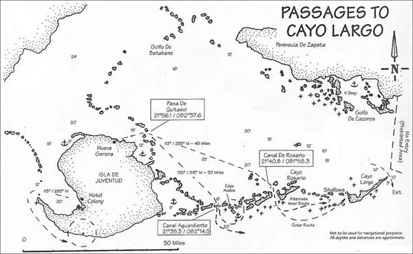
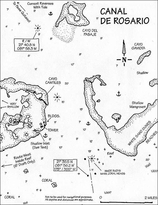
NUEVA GERONA Just inside the mouth of the river Las Casas and specializing mainly in the export of grapefruit and other citrus products, this commercial port has all Customs and Immigration facilities for international entry or departure. From outside, at 21°55.5N / 082°47.8W, markers lead in along a course of 218°M through a channel dredged to about 20 feet. Do not venture to the west of the channel as the dredged soil has been deposited into a bank there. Sometimes too, that very dredger and its barges are moored there. As you come in, be ready to avoid the large hydrofoils which speed in and out of the river delivering passengers to the other sideof the gulf of Batabano. These amazing Russian-built craft (Kometas), looking rather like something out of "The War of the Worlds," rise up on thin foils as they accelerate through the channel until they are some ten feet out of the water and travelling at a ferocious speed. Snorkelers in the channel (another thing to be aware of) take one startled look and dive, dive, dive; abandoning their rubber-tire rafts in a serious hurry to preserve life and limb. There is a Guarda Frontera post at the end of the markers in a collection of low white buildings dead ahead and on the right-hand bank. There isn't anywhere to moor, so draw up as close as you can and shout across for permission to enter. You will be directed to the main post some way in so continue slowly about one- mile along thenarrow river just off the large concrete wharfs, marine repair facilities, and the roadway. A MOST BEAUTIFUL SURPRISE Passing here in 1993 we received a most beautiful surprise when we encountered a group of about 15 tiny schoolchildren casually walking the road alongside the river bank, all beautifully neat in clean white shirts, red neckerchiefs, skirts and shorts. They immediately formed up a hurriedly measured arms length from each other, and in front of a beaming teacher they sang to us as we passed slowly in our boat! Sometimes, just sometimes, life is so sweet. THE PORT CAPTAIN'S OFFICE The first major building after the open areas which follow the commercial wharfs is the capitanfa (the port captain's office), so pull up on the right at a filthy, rundown wooden dock at 21°53.4N / 082°42.0W and explain your presence here. Despite that other sweeter welcome, the officials here can be a bit brusque, wondering just why you've chosen to interrupt their routine. Don't be fobbed off with excuses (no space/security), but present your papers showing your route with this stop mentioned. Indicate you'll be responsible for your own boat if something runs into it and you should be permitted to continue on to somewhere past the hydrofoil terminal on the right, a few hundred yards ahead of the bridge. In this instance, the officials are probably correct, there really isn't much space. But what's a little crowding among friends? Raft alongside the tugboats pressing together and settle in for your stay. Doubtless another official will show up to check on your final berth, but he will also be able to advise on the city so don't despair. They get very few private boats here, and you're probably the only entertainment they've had in a while. The river here is rather dirty, with small carcasses and empty grapefruit skins drifting idly downstream, but your neighbors will make you welcome, and as usual you will likely be taken on board various other vessels to visit. One rather unfortunate feature of the port is the incessant broadcasting of local radio stations over crackly speakers mounted on one of the larger boats nearby. You will not be happy after having to listen to the sugarcane harvest statistics for each province, random speeches by/to the local women's group, soap-operas, and dissertations on Congolese folk art. Immediately ashore you will find the large ancient ferryboat El Pinero used to transport Fidel Castro to prison on the island. Now up on blocks and scheduled someday (as much as anything ever is in Cuba) to be opened to the public, it makes a strange backdrop to a crowded mooring, especialiy contrasted with the rather "Flash Gordon" hydrofoils just downstream. Incidentally, you can take a ride over to the Cuban mainland on one of these: Purchase a ticket at the terminal 300 yards north of the bridge. They leave at three-hour intervals and the trip takes a bit more than two hours. The busiest part of Sown runs from Calle 32 at the bridge, north to Calle 18, between the riverside and the Calle 41. Note: The odd numbers run parallel to the river. There are a couple of official restaurants close to the center of town, but constant changes make it almost impossible to give a recommendation so make inquiries locally. There should in any case be a couple of paladars offering better value near your mooring site. Despite its rather flyblown aspect, the city is a friendly enough place, perhaps due to the influx of foreign students who made it their home in the boom years of Communism and the multitude of "International Youth Brigades" it spawned. Spend a day wandering aimlessly and you are bound to be kidnapped by someone or the other who invites you back (sometimes to a different town altogether) for tea. Transport around town can best be done by flagging down and sharing any of the horse-drawn carriages which ply the streets. They're also available for hire around the Parque Central at the junction of Calles 28/ 39, which is the best place to hang out in any case. If you wish to rent a car to tour the island then you can obtain one at the hotel some three quarters of a mile upstream under the bridge (go by dinghy). Crossing the bridge will take you to the old prison (the Presidio Modelo) some two-to-three miles east of town. Modelled on a prison in Illinois and now a museum, this is where Fidel Castro was imprisoned after the unsuccessful 1953 assault on the Moncado Barracks in Santiago. When clearing out, you will have to proceed one-quarter-mile upstream again to the Capitam'a for your despacho. The officials here are more accustomed to commercial vessels with more rigid schedules and their relative inexperience in matters concerning private boats will show. Stress that you cannot guarantee your exact schedule further down the line (you'll be anchoring out in the cays) and they'll finally get the picture. There is a "provedor" establishment (ship's chandlers) at the next major wharf along your route, so stop there on your way to the entrance if you need supplies for the next leg. It's the wharf with the big crane, where they haul-out the hydrofoils for maintenance. ROUTE TO CAYO LARGO CHART NOS. ICH 1145 & 1143 Once again, there are reports that the officials in the island are up to some new tricks. In contrast to elsewhere in Cuba the officials here will try to stiff you for clearance outwards, even if you are traveling within the country. Some yachts have been charged $10.00, so be prepared, and as before, don't lose your temper. Delay your departure until the afternoon and you will be able to find a sheltered anchorage dead east of North Gerona near the Pasa de Quitasol by early evening. The following leg is somewhat longer than desirable and an early start through the canal can enable you to make the passage without an intermediate stop. CAYOS DE LOS INGLESITOS (KEYS OF THE LITTLE ENGLISHMEN) Close to the dredged canal going through to the other side of the cays, this offers shelter from the east and northeast even if the holding is somewhat poor. Anchor as near to the edge of the cays as your keel allows, but do check your mooring carefully as the bottom is a thick mat of turtle-grass. If there is any chance of the wind rising you should double-check by diving and force it in manually if necessary (seeearlier chapter for our experiences here). In spite of the windbreak provided by Cayo Ingles we once carelessly allowed ourselves to drag over half a mile in the space of two hours when the wind got up to 25 knots. Luckily for us, we blew westwards into the bay instead of going ashore. PASA QUITASOL Prior to sunup you can make your way round to the western end of the canal at Quitasol and by the time the light is good you will be poised to go through from a position of 21°55.8N / 082°39.4W. Clearly marked, the canal runs 80°/260°M with a depth of 13 feet along its 1.5-mile length, and we have experienced strong through-currents on occasion. There is a freestanding wharf halfway along and some 400 yards north of the canal but otherwise the water is shallow on both sides. From the eastern end of the canal at 2r56.IN/082°37.6WtheGulfofBatabano opens wider still and you are over 30 miles away from the moderating influence of the mainland. Choose your route further on with regard to the forecast and wind direction. You may wish lo make your way directly across to the major exit through the outer keys at Cayo Rosario and while we have made this 45-mile run in perfect weather, this open run can also be subject to high winds. Our depth-sounder once drew pictures showing 8-10 feet waves over what was nominally only 16 feet of water. With the exception of the shallow passage through the cays at Aguardiente (follows) there are few closer outlets, and little real shelter before the main exit at Rosario, even if you can hide from the wind just west of the pass itself near the islands which extend northwards from Cayo Cantilles to Tabalones.
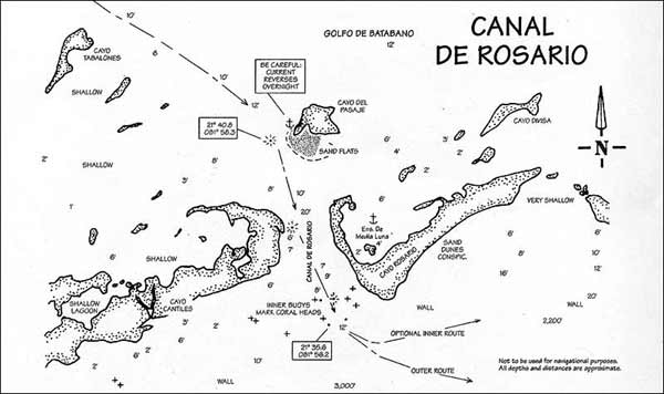
CANALIZO AGUARDIENTE An extremely convenient route through the chain of cays, and some 16 miles west of the Canal de Rosario, this well-marked pass is unfortunately limited by bars at both ends to vessels drawing six feet or less. From the north you may enter at 21°35.3N / 082°14.5W (160°/340°M) and once inside you will find a fantastic world of low mangrove, herons, diving cormorants, wading egrets, and creeks leading off the main channel. The canal itseif is a bit less than a mile long, 200 yards wide and some 10-20 feet deep in places. The southern end is at 2P33.9N / 082014.5W(10°/190°M)andismarkedbya concrete post with a rickety red triangle on top. As the water from within the gulf spills out, it seems to have scoured the bottom and the sands consequently are distinctly marked in a much lighter shade than the surrounding waters. Once again, there is a shallow bar here, but the water is clear and a boat drawing six feet or less can get through with care. CANAL DE ROSARIO
Carrying waters of eight feet, this is the main entrance/exit through the cays along the southeast gulf here. Due to the shallows further cast the only way to Cayo Largo is via the outside of the cays. This is the last chance to anchor overnight on the inside. Going the other way, vessels requiring nine feet had better resign themselves to using the outer route as far as the Isla de Juventud unless they are willing to spend some time picking through the shallows off the inner cay at Pasajes. If however, they make it past here, there is adequate water al 1 the way northwest to the Pasa Quitasol and through into the Gulf of Batabano. A course of 113°M from Quitasol should take you about a mile north of Cayo Tablones, then five miles further southeast to the Rosario Canal marker which will begin to show just southwest of Cayo Pasaje. That inner light, marking the beginning of the canal, is at 21M0.8N / 08I°58.3W, and despite its size bird droppings make it difficult to see from the northwest when the light is not working. You may anchorovernight, either side of Cayo Pasaje, but as before check the anchor carefully. Again, the bottom here is a mat of poor-holding grass and I have had to swim down to forcefully reposition the hook in a gully for additional grip. Note: The current through the canal can change direction 180° according to the tide, so make sure the hook cannot wriggle loose. In the more unusual event of a southeast wind then you can also enter the Media Luna lagoon inside Cayo Rosario itself. There is good bonefishing to be had there, but be careful about the wind swinging later, and pay close attention to your depfh. A few years ago we came in here to anchor overnight in this lagoon and encountered a large flock of pink flamingos wading in the shallows just south of Cayo Pasaje. Before that, the only other flamingos I'd seen were plastic, and lived on blue-rinse suburban lawns in Miami. The final 25-mile run to Cayo Largo can be accomplished only via the outside of the keys, so follow the lights out through the wide canal and turn east. The canal itself is quite wide, but the inner entrance/exit marks (21°35.9/081°56.3) denote a reef on either side and are set closer together, with the red inner marker on the eastern side standing directly on the reef. Although it is generally deeper, as before, if you draw more than eight feet, then exercise caution here with someone looking forwards and down at all time. For the best water stay closer to the eastern side of the channel. Go through the middle along 175°M to the two outer buoys 500 yards further on (2l°35.5 N / 081°56.2W) before making your turn. Note: When a storm is expected, this area is occasionally used as a shelter for boats moored at Cayo Largo 25 miles away. They tend to moor off Cayo Cantiles just to the south of the eastern entrance bank, where the land offers some protection. There is a small totally enclosed cove there too, at 21°36.9/081°58.3, but it only has anchor-room for one (or at most two), and is limited by depths of five feet at the entrance. If you can use this, as we've done in a northeaster, then get here early. The area is becoming more and more popular with cruisers, and that time we were amused to see at least seven or eight boats of all descriptions, ranging from charter cats and long-distance cruisers from Canada, to local ferrocement fishermen. A year or two previously there would only have been the latter. Around here too there are likely to be lots of occasions for bargaining for seafood and the like from passing craft.
ONWARDS Under normal conditions the sea will generally be quite calm and you can make the entire run from here to Cayo Largo in deep water, but in the event of a southeast wind the waves can easily be steep enough to persuade you to make this easterly passage through the shallower waters above and inside the wall. In the latter case you should exercise caution all the way. Although this is an easy run over sand, it is shallow in places and there are occasional coral banks, usually quite visible through the water. INNER ROUTE: Along this route, you will notice that all of a sudden there are pleasure craft of all descriptions using the sound, and if you are sufficiently aware and do not draw more than six or seven feet then you should have no trouble. Keep your depth-alarm turned up to loud and remain about a mile or two off the beaches. Look out particularly for the very obvious shoals south of the two small islets on the western tip of the Perases Cays. Just stay in the light green stuff, but avoid it if it gets loo pale. As you begin to see huts, cabanas, and semi-naked bodies, you are nearing the resort area. Turn north when you approach the western shores of La Sirena beach and the marked canal will take you in to the marina. OUTER ROUTE: Parallel the wall at anything around 21°32.5N until you're past the light at the western end of Cayo de Los Ballenatos. The various entries wii! follow 1.5 miles later.
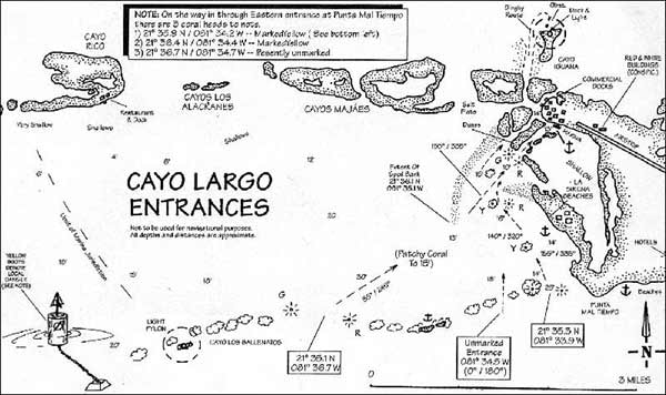
CAYO LARGO (A MARINA TO RESTORE YOUR FAITH) This is Cuba's premiere foreign tourist resort along the southern cays. Completely isolated and some 25 miles from the mainland, it consists of an excellent full-service marina, an airport, three or four hotels, wild dancing, loud music, and little else apart from superb white beaches, sparkling blue seas, fishing, and wonderful cruising. Due to it's distance from the coast it is not the place to go if you want mainstream Cuban life, but what it does offer the cruiser is possibly the best operated marina in Cuba; making it an. extremely civilized base for further exploration and a jump-off point to the eastern half of the country. Accolades must be offered to the staff here for their cooperative attitude to cruisers and their concern for them. This is one of the ports where some considerable charter business is done, principally by the K.P.Winter concern which has entered into a partnership with PuertoSol, the Cuban tourist enterprise. The majority of the boats in use are cruising catamarans, chartered for a week or more by foreign visitors. REEF ENTRANCES (From Outside) Not clearly shown on the normally precise Cuban ICH charts, this entry has been radically changed over the last two years and there are now two marked entrances (with an additional unmarked one between them). A considerable quantity of dredging spoil has also created a shallow bank before the final approach to the docks, so the following sketch chart should be consulted and my previous instructions (in the original edition of this guide) should be modified as follows... Western: The main western channel-markers are 1.5 miles east of the light and consist of two R/G lighted buoys at 21°35.1 N / 081°36.7W some 500 yards apart. Enter in 35 ft., then aim 55"M over an undulating bottom of corals and sand to the end of a submerged (but visible) bank consisting of the spoil from eariier dredging operations. Pass round the southern tip of this bank and head 40"M to the entry marks at the marina canal. On this final approach, if the spoil bank has been further extended, aim to miss the cora! head at 21°36.4/ 081°34.6 and pass between it and the red mark closer to the eastern shore. Eastern: Just west of the large main island of Cayo Largo, is a new marked entrance consisting of two lighted buoys at 21°35.3N/081°33.9W. This carries 25 feet of water and should be entered on a northerly course. Immediately upon entering, take up a course of 335°M to pass east of a mark sitting on a coral head at 21°35.8/ 08T34.2 by which time the depth will be around 14 feet. Continue on 320°M for a short distance to another mark over a coral head at 21°36.4/081*34.6, whereupon you can swerve round the spit of sand coming out from the shoreline and proceed to the entry mark for the marina channel just to the northeast. Middle Entrance: This is an unmarked entry, but occasionally it is convenient and I have used it several times. It is situated at 081°34.5 W and you come in from outside along a north/south course straight for the marina canal. You must look out for any unexpected surprises below, but having said that, with care you should find at least 10 feet minimum depth along this route.
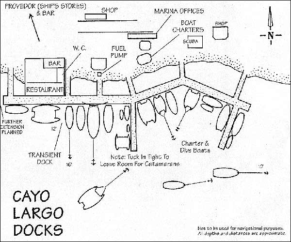
FINAL APPROACH AND DOCKING Hidden by dunes and vegetation, you cannot see the marina from outside, but there are two large sentry-box markers at position2J036.9N/08i°34.4Winl5feetof water. These mark the final short canal passing between a sandy cay lo port and some shallows to the starboard. Depths along this route are some 13 feet and at the far end you will see the docks immediately ahead over to the starboard. If you have previously been in contact (advisable) on VHP channels 16/19 there will be someone waiting at dockside with assistance and instructions. If not, then approach the docks carefully (there is good deep water here) and shout over to any of a couple of dozen yachts or power boats here. Someone will certainly give you a hand with the docking. The dock area immediately in front of the large thatched bar/restaurant is usually occupied by tourist canoes and the like, but during the day it is usually vacant, and if so you may be able to moor there temporarily while sorting out your documents. The marina is likely to be crowded by a mixture of charter and foreign sailboats, all jammed together in a cheerful rabble. And of course, interspersed among them will be a number of local dive and fishing boats, not to mention the large Polynesian-style outrigger canoes which take the hotels' tourists over to the various cays for the day. Far from the miserly twenty boats a year it used to attract in the years before 1995, the last time I stayed there (just prior to beginning this edition) I counted some 35 boats moored alongside, and about 10 more at anchor in the canal just in front of the docks. When a berth is available, you will almost certainly be required to Med-Moor (i.e. moor stern-on to the dock) which is a thrill if you haven't done it before. Med-Mooring: With ample fenders hung on both sides, come to a halt some 30 - 40 yards off your intended docking space and spin your craft into a 180° turn so that the stern points directly at the spot where you wish to tie up. Lower the bow-anchor at this point, and with the rode (anchor-line) playing out freely, reverse slowly, making frequent corrections to ensure you're not biased to one side or the other. When you're a comfortable distance from the dock throw a pair of stern Sines to the helpers ashore and hurry forwards to snub up the main anchor line. Allow those ashore to pull you in against the resistance of the anchor digging in, and if you've got it right you will remain a foot or two off the dock but still firmly held fore and aft. At this point the various lines should be adjusted for fit and the stern lines crossed. It's always a blast when you get it right, and with care it's not half so difficult as it sounds. Note: If the docks are too crowded then you may have to anchor out in the channel among the other boats there. The holding is good in the channel, but does consist of soft mud on top, so use the anchor best suited to the task. A Danforth or some such hook, with nice wide flukes, is best here. In a strong easterly I have seen a new arrival drift back some fifty yards or more before he got a good grip on the bottom. |